


Going Back
By Gregg Treinish
October 30, 2007
So we are back and it feels good. I love that I actually forgot how much I missed being down here and didn't realize it until I got back. Perhaps the struggle at the end of the last section was a contributor to the fact. Seems funny saying that too, this section really has been nothing but difficult. We turned back for the first time on the trip as it wasn't safe to continue in the direction that we were. We have both been sick already. We have already had to swim across a lake fed entirely by snow runoff. We have crossed nearly a hundred miles of snowfields, post-holeing through most of them. We have crossed rivers partially covered with snow and have crossed miles of lava fields which bring entirely new dangers to the table than ever before. There is some part of me though, something deep inside that is just better when I am outside, moving, exploring, it really doesn't matter how difficult it is.
When we left in September to go home, there was a small part of me that was scared that something would go wrong, that we somehow, despite all the desire in the world to finish this thing right, wouldn't make it back down here. It still wasn't a sure thing until we landed in Santiago. Getting off of the plane for the second time was entirely different than the first. Simply knowing what to expect makes a world of difference. We still didn't know where to go, where we'd be staying, or who we'd meet, but this time none of that mattered much. After 14 months of not knowing what the next corner would hold, our arrival back in Santiago was simply the next turn, the next resupply before we headed back out into field for the next section. In hindsight our comfort was probably the reason we would wind up turning around and heading back to Santiago after just two days of hiking.
We had climbed high out of town, more than 6000 feet the first day. Our biggest concern was and had been the snow for sometime. As we climbed back up into the mountains and reached that very first saddle, it quickly became clear that our worry was in fact justified. To the north, the west, and the east, there wasn't a break in the snow, there wasn't a single peak that wasn't completely covered with the remnants of what the locals tell us was an exceptionally cold winter. We maintained our hopes that somehow, someway we would catch a break and the peaks just on the edge of the Andes would be dry to the south. It was the only direction that we couldn't see and this was enough reason to keep going. So after a cold night at a mere 8000 feet, we woke early and headed south on a low ridge. Our excitement grew and it seemed that we actually must've lucked out after all. The ridges at that altitude were bare, and walking was possible and absolutely as beautiful as it has ever been. We walked on, both commenting on how good it was to be back in the air (despite the fact that the brown cloud hovering over Santiago was still very much part of it), how great it was to hike and not feel rushed by a lack of time, by plane tickets, or a lack of food. Two hours later the mood would change. The ridge on which we had been walking took a sharp turn to the east and with it, our route grew impassibly steep; we'd need a different strategy. To the south was a 4000 foot descent to the central valley that we knew was at least a 60 degree slope that we'd have to be careful and lucky to get down safely. Going toward the north was for obvious reasons not an option, and to the west, the snows grew deeper, and we knew also not an option. Despite the ominous signs of the condors circling overhead we headed down to the south and even managed to have some fun sledding on the snow that is still in the crevices of the valley where the sun hasn't yet had it's chance to eliminate winter's work. We must have descended 2500 feet before merging with a bigger river valley and very quickly realizing that we again were S.O.L. Waterfalls more than 100 feet high were bordered on both sides by 70-80 degree cliffs; on our first section out of Santiago we ran out of options. We climbed back up the valley we had just descended and actually weren't as upset as you might think. It was really that good to be hiking again. In fact, I wasn't really that upset about the situation until we were back in the heart of Santiago, on the subway yet again and back to square one of having to resupply, and get maps. Nearly a week had passed since we had returned to Chile, and we had progressed zero miles closer Cape Horn...bad news.
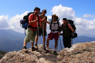
With the snow too much of a threat, and the thought of possibly having to turn back yet again simply devastating, we decided to have a go at the much smaller, but equally beautiful coastal range. Though not officially part of the Andes chain, the two are a mere 30 miles apart, so we still count the miles. While the Cordillera Coastal is indeed lower down, it is also equally as steep and the climbs nearly as big, partially for this reason we were shocked to run into the first backpackers that we have seen on the entire trip. Claudio, Alfredo (Veto), and Felipe are all from Santiago, and are the best kind of weekend warriors. We were thrilled to have friends to hike with, thrilled to know that there was indeed a trail and that we were with someone who knew where it went. The five of us would hike together for the next two days, having as much fun at camp as we have since Paul was with us months ago. The promise that the simple sight of others who actually care about the outdoors brings for the months to come is overwhelmingly uplifting. The fact that Veto wanted to come along for the rest of our hike into Rancagua was equally as exciting. Veto had never made the four day hike to Rancagua either, but confirmed that it was indeed possible and that some of his friends had done it years prior. I guarantee that they didn't take the same route as us. On the fourth day, the one in which we were due to get to town, we followed a dirt road that clearly was going to the pass above the valley where we had spent the night. The road ended, Deia thought it might be quicker to go back down and around, I disagreed. Soon we were bushwhacking straight up the sides of an entirely too steep, cliffed-out mountainside. The prickers at some points became so thick that I was getting stabbed from all four directions at once, moving quicker than a tenth of a mile per hour was a dream at best. It would take six hours to reach the end of the fight and the top of the mountain. With no water, and all severely cut up, we would make good on our promise to reach town and would hike into the night. Section One was finally complete, we were tired.
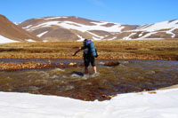
The biggest question upon our arrival in Rancagua was, "What next?" the Costal Range gets dramatically flatter south of town, and therefore really wasn't an option, after all we are walking this continent in the mountains. This made the only real option a return to the Andes with the hopes that staying down low enough would allow us to sneak by below the snowline, and only have to cross through the snow on the passes...WRONG! Before day two was over we knew that we'd have cold feet for a while to come. An unbroken blanket sometimes in excess of twelve feet thick is still very much covering the Andes, still very much an obstacle. Fortunately in the beginning, we were able to stay on top of the snow. We knew that if we began post-holeing (falling through the snow) we would be in serious trouble of not only injuring ourselves, but we'd also be slowed to a crawl. We cautiously continued on, crossing rivers in the snow, some so deep that at one point Deia lost her footing and was swept downstream a ways, she managed to scurry to safety a bit shaken up, and extremely cold. I fell through a snow bridge landing in a river, soaking myself from head to toe. I was lucky to find a hot spring nearby and warm up quickly. At one point we came to a lava field (the lava wasn't still hot) more than 50 square miles, we tried to cross in the snow, and almost immediately were falling through and landing on the jagged lava below. Changing course we headed east and out of the Lava, what we discovered was perhaps one of my favorite spots we have come to on the trip thus far. As we approached the edge of the lava field, steam rose from behind mountains of ash and rock; we had come upon the largest hot springs either of us have ever seen. A river of naturally heated water would flow for two miles, not only providing a much needed bathing facility, but more importantly melting the snow allowing us to travel on dry ash. Much easier, much quicker, much safer. As we descended and left the last of the snow, I remember feeling a tremendous sense of relief, we had made proper decisions to get ourselves down and out of a potentially very bad situation. My relief came a bit too soon. Still on the tailings of the lava flow, the next morning we would awake to find ourselves smack in the middle of a ash/sand storm. At least twice, Deia and I could not see one another less than 10 feet apart. Winds were strong, but the sand being whipped against our faces was worse. We pushed through the storm and made our way to Lago Invernada and out of the wind. On our maps, there is a trail around the northwest side of the lake, we were home free. In reality, the lake is flooded and no such trail exists. With sheer cliffs on all sides and more than two miles of water between us and the valley we'd need to walk down to get to town and get some food (we had since run out), we were very much wondering what the hell we were gonna do. Knowing that swimming in 30-35 degree water could be very dangerous, we decided to have a go at rock climbing around the side of the lake. We made it a good half mile traversing on a boulder field before we could go no further. Into the water we went, ten minutes and not much further along, out we came. We had intentions of warming up a bit and continuing on. I started shivering violently, Deia soon followed, it wasn't smart to go back in the water with the sun having dipped behind the mountains. We took refuge on a rock slide and spent a very uncomfortable night wondering how far we'd have to swim in the morning, however far it was, at least we'd have sun. We woke up late, giving the sun a chance to warm things up, waterproofed all of our cloths, sleeping bags, etc. and headed down to the water. Within seconds 20 mph winds kicked up out of nowhere and left us feeling cold out of the water and a bit scared to go in. We waited, nothing changed. Three hours passed as we looked for other routes up, around, back, there was simply nothing. Back in the water we went, we swam for a while, our packs on our back as always and after a few minutes stopped to warm up, made some tea, put on dry clothes, then did it all over again.

We made our way to the other side of the lake around 5pm, more than 30 hrs after we could first see the lake, we were happy! The trail which was apparently under water around the lake eventually gave way to a dirt road. Very proud of the choices we had made and that we had managed to keep ourselves safe throughout the week, and very appreciative of the luck we had, we rapidly descended towards food. Following in the tradition of almost everyone we have met down here so far, some really kind folk working for a hydro-electric company became our trail-angels and made us some sandwiches for the road. We are now in Talca figuring out where we next want to head. We are less than 200 miles from Arucania which will mark our entrance into Patagonia. EXCITED! Don't worry, we don't plan on repeating this past week's experiences again.